The Mt Albert Historical Society focuses on the area that used to be Mt Albert City Council. This includes the suburbs of Mt Albert, Sandringham, Morningside and Kingsland.
This page lists all street names (current, and historical) from this area, and indicates name changes wherever possible.
You can find all mentions of a street or address in our newsletters and on pages of our website by using the Search box at the top of every page.
The map below is an edited version of the 1930s Leighton Map of Auckland, from Auckland Libraries. These two maps from 1924 show the boundaries of Mt Albert Borough and the Streets within it very clearly – the North and the South parts of the Borough. A 1979 version of the Mt Albert City map can be found on the Kerr-Taylor Foundation website. Each of these maps can be enlarged by clicking on them.

A B C D E F G H I J K L M N O P Q R S T U V W X Y Z
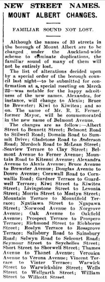
Bold text = current street names / Plain text = former street names
- Ace Pl (earlier name Akepiro St (part), Arnold St (part), Edwin St (part)) C1 Kingsland
- Aitken Tce (west from Aitken Reserve) C1 Kingsland
- Akepiro St (part)[earlier names Arnold St (part), Edwin St (part); renamed Ace Pl 1988]. C1 Kingsland
- Alamein Tce A3 Mt Albert
- Albert Ave [renamed Albert St, then Bennett St 1938] B2 Mt Albert
- Albert Rd [renamed Soljak Pl 2000] A2 Mt Albert
- Albert St [renamed Bennett St 1938] B2 Mt Albert
- Albert St [renamed William St, then Willcott St 1938] A2 Mt Albert
- Alberton Ave [earlier name Rob Roy St until 1920s] B2 Mt Albert
- Alexander St (west side) C1 Kingsland
- Alexandra Ave [earlier name Chapel St; renamed Alexis Ave 1938] B2 Mt Albert
- Alexis Ave [earlier names Chapel St, Alexandra Ave to 1938] B2 Mt Albert
- Allendale Rd A2 Mt Albert
- Altham Ave C1 Morningside
- Amandale Ave B1 Mt Albert
- Ambrose St
- Anderson Rd [renamed Gladstone Rd, Carrington Rd] A2 Mt Albert
- Arabi St C2
- Argyle St [renamed Morningside Dr (part)] B1
- Arnold St (part) [earlier name Edwin St, renamed Akepiro St 1938 then Ace Place 1988] C1 Kingsland
- Aroha Ave [lower end earlier name Troonville Ave] B1 B2 C2
- Asquith Ave [earlier names Whau Rd, Old Whau Rd, Old North Rd, Avondale Rd to 1912. Renamed Malvern Rd (part) 1983] A2 B1 B2 Mt Albert
- Atawhai Ln B2
Avondale Rd [renamed Asquith Ave and Malvern Rd 1912] A2 B1 B2
Mt Albert- Baldwin Ave B1 B2
- Ballast Lane A2
- Balmoral Rd (West from #234)[earlier names Edendale Rd to 1912] C2
- Bank St [renamed Phyllis St] A2 Mt Albert
- Bannerman St (east from Derwent St) B1
- Barrymore Rd A3 Owairaka
- Begbie Pl C2
- Belmont Ave [renamed Ferner Ave 1938] A2
- Belmont Rd [renamed Stilwell Rd 1938] A2
- Benfield Ave [earlier names Counsel Tce (west part) or Old Counsel Terrace (west part) (to #13) to 1912, West St and Frederick St to 1928] A2 Mt Albert
- Bennett St [earlier name Albert St to 1938] B2
- Bollard Ave (north end)[earlier name Quarry Rd to 1912] A3
- Bond St (south end) C1
- Bournemouth Ave B2
- Braemar Tce A2 Mt Albert
- Brewster Ave [earlier name Bruce Ave to 1938] B1
- Bruce Ave [renamed Brewster Ave 1938] B1
- Buchanan St C1
- Burch St B2
- Burnley Tce (west from #51/58) [earlier name Reston Rd to 1906] C1
Burnside Ave B1
Mt Albert- Cabbage Tree Swamp Dr C2
- Cabbage Tree Swamp Rd [renamed Kingsland Rd 1877, Sandringham Rd] C2
- Calgary St (West from Kiwitea St, #39/44) B2 C2
- Cambourne Rd (west from #37/44) C2
- Camden Rd B2
- Carrie St B2
- Carrington Rd [earlier names Mt Albert Rd West, (part) Onehunga-Mount Albert Rd to 1916, (part) Gladstone Rd to 1938] A2 Mt Albert
- Cassino Tce A3 Owairaka
- Caughey Pl A2
- Central Rd (south end) [earlier names Glen Osborne Rd, Glenmore Rd, Commercial Rd to 1932] C1
- Challenger St [renamed Challinor Cres] B1 Mt Albert
- Challinor Cres [earlier name Challenger St] B1 Mt Albert
- Chapel St [renamed Alexandra Ave to 1938, Alexis Ave] B2 Mt Albert
- Charles St (to corner Akepiro St) C1
- Chatham Ave (south of Norgrove Ave) A1 Mt Albert
- Clarke St [renamed Sandringham Rd (part) C1 C2 B2 B3
- Clay St [briefly the name of Seaview Tce c 1938] A2 Mt Albert
- Collins St C1
- Columbia Rd B3
- Commercial Rd (south end) [renamed Central Rd 1932] C1
- Cornwall St/Rd [renamed Cornwallis St 1938] B2
- Cornwallis St [earlier name Cornwall St/Rd] B2
- Coronation Rd [renamed Hampstead Rd] B2
- Councillors Dr B2
- Counsel Tce (west) [later West St 1912, Benfield Ave from 1928] A2 Mt Albert
- Counsel Tce A2 Mt Albert
- Coyle St B2
- Cromwell St [earlier name John St to 1912] C1
- Cricket Ave [earlier name Milton St 1906] C1
- Cross St [renamed Duncan Ave] B2 B3
Crown St [now part of Eden Park] C1
- Delphine Cl B3 Owairaka
- Derwent St (east side) [earlier name Waverley St to 1937] B1
- Domain Rd [renamed Summit Dr 1938] A2 B2 Mt Albert
- Don Croot St B1
- Doreen Ave B1 Mt Albert
- Douglas Ave A2 Mt Albert
- Duart Ave A2 Mt Albert
- Duke St [now part of Eden Park] C1
- Duncan Ave [earlier name Cross St] B2 B3
- Duncan Maclean Link B1
Dunkirk Tce A3
Owairaka- Eden Dale Rd [part was renamed Sandringham Rd from 1929] C1, C2, B2, B3
- Eden View Rd B3
- Edendale Rd [part was renamed Balmoral Rd (west from #234) to 1912] C2
- Edendale Rd [part was renamed Sandringham Rd from 1929] C1, C2, B2, B3
- Edwin St (part) [renamed Arnold St, then Akepiro St 1938 then Ace Place 1988] C1 Kingsland
- Elizabeth St (west from #50) [renamed Gribblehirst Rd 1932] C2
- Emma St [renamed Marlborough St] C1
- Ennismore Rd A2 A3 Owairaka
- Epsom-Mt Albert Rd [part was renamed Edendale Rd] C1 C2 B2 B3
- Ethel St C1
- Euston Rd B2 B3
Exeter Rd B2
- Fairleigh Ave A2 Mt Albert
- Farrer St [renamed Laurel St] A2
- Fergusson Ave B2
- Ferner Ave [earlier name Belmont Ave to 1938] A2 Mt Albert
- Finch St B1
- First Ave C1
- Fourth Ave C1
- Fowlds Ave B2 B3
- Fowler Ave A2
- Francis Ryan Cl B2
- Frederick St [earlier name West St 1912; renamed Benfield Ave 1928] A2 Mt Albert
Freyberg Ave C3
- Gardiner Tce [renamed Guardwell Tce 1938] A1 Mt Albert
- Gardner Tce [renamed Guardwell Tce 1938] A1 Mt Albert
- George St [earlier name Hori St to 1916] C1
- George St West [part of George St] C1
- Gladstone Rd [earlier name Anderson Rd to 1938; renamed Carrington Rd] A2 Mt Albert
- Glenmore Rd [renamed Central Rd] C1
- Glen Osborne Rd [renamed Central Rd] C1
- Glentui Rd A3 Owairaka
- Gordon Rd [renamed Morningside Dr (part)] B1 B2
- Goring Rd C2
- Grand Ave [alternate spelling Grande Ave] A2 Mt Albert
- Grande Ave [alternate spelling Grand Ave] A2 Mt Albert
- Grant St
- Gribblehirst Rd [earlier name Elizabeth St (part)] C2
- Grove Rd B2 C2
- Grove Tce [renamed Sadgrove Tce] B2 Mt Albert
Guardwell Tce [earlier name Gardner / Gardiner Tce to 1938] A1
Mt Albert- Halesowen Ave (west from Pine St) B2 C2
- Hallam St B3
- Hampstead Rd [earlier name Coronation Rd] B2
- Hansen Rd [renamed Marne Ave 1916] B3
- Harbutt Ave A2 Mt Albert
- Hargest Tce A3 Owairaka
- Harlston Rd A2 A3 Owairaka
- Harwood St [earlier name Rimu St] B3 C3
- Haverstock Rd [earlier name Mania Rd to 1916] B2 B3
- Hazelmere Rd B2
- Hendon Ave A3 Owairaka
- Herbert Rd [renamed Raetihi Cres] A2 Mt Albert
- Hesketh St C1
- Highland Rd B3 Owairaka
- Hillside Tce [renamed Ruarangi Rd 1932] B2 Mt Albert / Owairaka
- Hori St [renamed George St 1916] C1
- Hulse Ave B2
Inwood St B1
- Jason Ave C2
- Jennings St A2 Mt Albert
- Jerram St A2 Mt Albert
- Jersey Ave A2 Mt Albert
- Jesmond Tce B1
- John St [renamed Cromwell St 1912] C1
- Kenneth Ave B2 C2
- Kerr St B2
- Kerr Taylor Ave B2 Mt Albert
- King St (from #55, earlier known as King St South) C1
- King St South (renamed King St) C1
- King Edward St (west from #44/47) C2
- Kingsland Ave C1
- Kingsland Rd [earlier names Cabbage Tree Swamp Rd, New Edendale Rd 1912, Edendale Rd 1916. Renamed Sandringham Rd] C1 C2
- Kingsland Tce C1
- Kingsway Ave B2
- Kitchener Rd B2
- Kitenui Ave [earlier name Mountain Rd to 1938] B2
- Kiwi St [renamed Kiwitea St 1938] B3 C3
- Kiwitea St [earlier name Kiwi St to 1938] B3 C3
- Knight Ave A2
Kowhai St C1
- La Veta Ave A2 A3 Mt Albert / Owairaka
- Lambeth Rd (from #64/67) [earlier name Puriri St] C3
- Lancing Rd C2
- Laurel St [earlier name Farrer St] A2 Mt Albert
- Leone Tce A1 Mt Albert
- Leslie Ave B1 C1
- Levonia St [earlier name Livingstone St to 1938] B1
- Linwood Ave [earlier part of Challinor Cres to 1925] B1 Mt Albert
- Livingston St [renamed Levonia St 1938] B1
- Lloyd Ave [earlier name Lloyd Ave East] A2 B2 Mt Albert
- Lloyd Ave East [renamed Lloyd Ave] A2 B2 Mt Albert
- Lloyd Ave West [earlier name Mary’s Lane to 1916, renamed Lloyd Ave] A2 Mt Albert
- Locarno Ave B2
- Lorraine Ave B3 Owairaka
- Lyon Ave B2
- McDonald St B1 C1
- McGehan Cl B3 Owairaka
- McLean St [earlier name Murdoch Rd to 1938] A2 Mt Albert
- Malvern Rd [earlier names Old Whau Rd; Asquith Ave to 1982. Part renamed Seymour Rd 1938] B1
- Mania Rd [renamed Haverstock Rd 1916] B2 B3
- Margaret Ave (south of #49/#42) A1 Mt Albert
- Mark Rd A2 Mt Albert
- Marlborough St (north of #25/#36) [earlier name Emma St] C1
- Marne Rd/Ave (earlier name Hansen Rd to 1916] B3
- Mars Ave C2
- Martin Ave [earlier name Parkstone Rd] B1 Mt Albert
- Mary’s Lane [renamed Lloyd Ave West 1916] A2 Mt Albert
- Maybeck Rd B2
- Milton St [renamed Cricket Ave 1906] C1
- Monaghan St?
- Moreland Rd A2 Owairaka
- Morningside Dr [earlier names Gordon Rd (part), Argyle St (part)] B1 B2
- Morning Star Pl B2
- Morrin St [renamed Mostyn St 1938] C1
- Mostyn St [earlier name Morrin St to 1938] C1
- Mt Albert Rd [earlier names Three Kings Rd, Onehunga-Mt Albert Rd, Mt Albert Rd East] A2 B2 B3 Mt Albert / Owairaka / Sandringham
- Mt Albert Rd East [Renamed Mt Albert Rd] A2 B2 B3 Mt Albert / Owairaka / Sandringham
- Mt Albert Rd West [renamed Carrington Rd] A2 Mt Albert
- Mt Royal Ave B2 Mt Albert / Owairaka
- Mountain Rd [renamed Kitenui Ave 1938] B2
- Mountain Tce [renamed Mountfield Tce 1938] B3 Owairaka
- Mountain View Rd B1
- Mountfield Tce [earlier name Mountain Tce to 1938] B3 Owairaka
- Murdoch St [renamed McLean St 1938] A2 Mt Albert
- New Bond St C1
- New Edendale Rd [renamed Sandringham Rd] C1 C2
- New Great North Road [renamed New North Rd c1875] A2 B1 B2 C1
- New North Rd (#322 to #1230) [earlier name New Great North Rd to c 1875, Whau Rd (part)] A2 B1 B2 C1 Kingsland / Morningside / Mt Albert / Owairaka
- Newcastle Tce A2 Mt Albert
- Ngapawa St [earlier name Ngatiawa St to 1938] C2
- Ngatiawa St [renamed Ngapawa St 1938] C2
- Norgrove Ave [earlier name Norwood Ave to 1938] A1 Mt Albert
- Norman St (west part) [renamed Tawari St] C1
- Norrie Ave B1 Mt Albert
- Norwood Ave [renamed Norgrove Ave 1938] A1 Mt Albert
- Oak Ave [renamed Oakfield Ave 1938] B2
- Oakfield Ave [earlier name Oak Ave to 1938] B2
- Old Counsel Tce [renamed West St 1912; renamed Benfield Ave 1928] A2 Mt Albert
- Old North Rd [renamed Asquith Ave (part) A2 B1 B2 Mt Albert
- Old Whau Rd [renamed Asquith Ave (part), Malvern Rd (part)] A2 B1 B2 Mt Albert
- Olympus St A3 Owairaka
- Onehunga-Mt Albert Rd [renamed Mt Albert Rd] A2 B2 B3 Mt Albert / Owairaka / Sandringham
- Onslow Rd (west of Cromwell St) C1
- Owairaka Ave [earlier name Vincent Rd] A3 B3 Owairaka
Oxton Rd [earlier name Rosemary St] C2
- Paice Ave (west from #45/46) C2
- Papori Lane A2
- Park Rd [renamed Renton Rd] A2 Mt Albert
- Parkhill Rd B1
- Parkstone Rd [renamed Martin Ave] A1 Mt Albert
- Parrish Rd C2
- Parry St [earlier name Totara St] B3 C3
- Patterson St/Rd C2
- Phyllis St [earlier name Bank St] A2 Mt Albert
- Pickens Cres A3 Mt Albert
- Pickett Ave B2
- Preston Ave A2 Owairaka
- Princes St [now part of Eden Park] C1
- Prospect Tce [renamed Prospero Tce 1938] A2 Mt Albert
- Prospero Tce [earlier name Prospect Tce to 1938] A2 Mt Albert
- Puriri St [renamed Lambeth Rd] C3
- Quarry Rd (north end)[renamed Bollard Ave 1912] A3
Queen St [renamed Reimers Ave 1906] C1
- Raetihi Cres [earlier name Herbert Rd] A2 Mt Albert
- Range View Rd A3 Owairaka
- Ranleigh Rd A2 B2
- Reimers Ave [earlier name Queen St to 1906] C1
- Renfrew Ave (west side) C3
- Renton Rd [earlier name Park Rd] A2 Mt Albert
- Reston Rd (west from #51/58) [renamed Burnley Tce 1906] C1
- Rhodes Ave A2 Mt Albert
- Richardson Rd (to numbers 162/163) A2 A3 Mt Albert / Owairaka
- Richborne St [earlier name Richmond St to 1938; renamed Richbourne St 1985] C1
- Richbourne St [earlier names Richmond St to 1938; Richborne St to 1985] C1
- Richmond St [renamed Richborne St 1938] C1
- Rimu St [renamed Harwood St] B3 C3
- Rob Roy St [renamed Alberton Ave in 1920s] B2 Mt Albert
- Rocky Nook Ave [earlier name (part) Seymour St, Malvern Rd (part)] B1
- Rosemary St [renamed Oxton Rd] C2
- Roslyn Ave [renamed Rossgrove Tce 1938] B1 Mt Albert
- Rossgrove Tce [earlier name Roslyn Tce to 1938] B1 Mt Albert
- Rossmay Tce C1
- Royal Tce C1
Ruarangi Rd [earlier name Hillside Tce to 1932] B2
Mt Albert / Owairaka- Sadgrove Tce [earlier name Grove Tce] B2 Mt Albert
- Sainsbury Rd [earlier name Salisbury Rd to 1938] B1 B2
- Saint Lukes Rd B2 Mt Albert / St Lukes
- Salisbury Rd [renamed Sainsbury Rd 1938] B1 B2
- Sandringham Rd [earlier names Cabbage Tree Swamp Rd, Kingsland Rd, Edendale Rd (part), New Edendale Rd 1929, Clarke St (part)] B2 B3 C1 C2
- School Rd C1
- Seaview Tce [sometimes entered as Sea View, earlier name Clay St (briefly) c 1938] A2 Mt Albert
- Second Ave C1
- Selcourt Rd [earlier name Selwyn Rd 1938] B1 B2
- Selkirk Rd B1
- Selwyn Rd [renamed Selcourt Rd 1938] B1 B2
- Seychelles St [earlier part of Seymour St to 1938] B1
- Seymour St [became part of Rocky Nook Ave, Malvern Rd and Seychelles St 1938] B1
- Shaw St C1
- Short St [renamed Shorwell St] B2
- Shorwell St [earlier name Short St] B2
- Soljak Pl [earlier name Albert Rd to 2000] A2 Mt Albert
- Spring St [renamed Springfield Rd] B1
- Springfield Rd (east from #12/19)[earlier name Spring St] B1
- Springleigh Ave A2 Mt Albert
- Stewart Rd A3 Owairaka
- Stilwell Rd [earlier name Belmont Rd to 1938] A2 Mt Albert
- Mt Albert
- Taumata Rd B2 B3
- Tawari St (west part) [earlier name Norman St] C1
- Taylors Rd B2
- Thames Ave [renamed Thanet Ave 1938] B2 C2
- Thanet Ave [earlier name Thames Ave to 1938] B2 C2
- Third Ave C1
- Thomas Ave A2 Mt Albert
- Three Kings Rd [renamed Mt Albert Rd] A2 B2 B3 Mt Albert / Owairaka / Sandringham
- Ti Kouka Ln B2
- Toroa Tce B2 Mt Albert
- Totara St [renamed Parry St] B3 C3
- Tranmere Rd C2
- Troonville Ave [renamed Aroha Ave] B2 C2
Truro Rd C2
- Vancouver Ave/St B3
- Verona Ave [earlier name Veronica Ave to 1938] A1 Mt Albert
- Veronica Ave [renamed Verona Ave 1938] A1 Mt Albert
- Victoria Ave [renamed Violet St] B2
- Vincent Rd [renamed Owairaka Ave] A3 B3 Owairaka
- Vincent Tce [renamed Vinter Tce 1938] B2 B3
- Vinter Tce [earlier name Vincent Tce to 1938] B2 B3 Owairaka
Violet St [earlier name Victoria Ave] B2
Wagener Pl B2
Wairere Ave B1 B2
Walters Rd (west from #5/6) C1
- Ward Tce C2
- Warwick St [earlier names Wexford St, Warwickshire St to 1938] B1
- Warwickshire St [renamed Warwick St 1938] B1
- Watea Rd [earlier name Water St] B2 B3
- Water St [renamed Watea St] B2 B3
- Watson Ave B2 C2
- Waverley St [renamed Derwent St 1935 ] B1
- Wellgarth St [earlier name Wells St to 1938] C1
- Wells St [renamed Wellgarth St 1938] C1
- Wesley Ave B2
- West St [earlier name Counsel Tce [west part] or Old Counsel Tce to 1912; renamed Benfield Ave 1928] A2 Mt Albert
- Western Springs Rd B1
- Weston Ave A2 Mt Albert
- Wexford St [renamed Warwick St 1938] B1
- Whau Rd [renamed Asquith Ave (part), Malvern Rd (part), New North Rd (part)] A2 B1 B2
- Willcott St [earlier name William St to 1938, also Albert St] A2 Mt Albert
- Willcott Mews Ln A2 Mt Albert
- William St [earlier name Albert St; renamed Willcott St 1938] A2 Mt Albert
- Willis St B2
- Wolseley St B1
- Woodward Rd A2 Mt Albert
Information on this page is largely drawn from the Auckland Street Names database at Auckland Libraries.